Cycle GPS Logger app for iPhone and iPad
Developer: Yukiko Iwai
First release : 11 Apr 2015
App size: 3.64 Mb
1. Display your position on the map
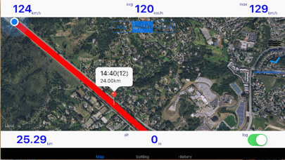
Current speed, average speed, maximum speed and altitude are displayed.
Standard functions of iOS Maps is implemented.
Also landscape orientation is supported.
2. Display your cycling trail on the map
By sliding "log" switch, the tracking mode is started.
The total distance is displayed at the lower left.
3. Replay and Transfer your cycling trail
To choose a past cycling trail from "History" tab, you can view it on the map.
And you can pull it from iPhone via email or iTunes(Finder in macOS 10.15 or later) as a CSV file.
The CSV file can be edited with Excel etc.
4. Allow offline viewing
Without cellular data service, the tracking function is available.
You can reduce data traffic and power consumption.
5. Run in sleep mode
To enable "Background" in "Setting" tab, you can use the tracking function even when iPhone in your pocket.
[CAUTION]
Continued use of GPS running in the background can dramatically decrease battery life.


